The Faithful Gather
One family has dominated Poynton for over 600 years, the Warren family. Edward Warren became Baron Stockport in 1332 and he purchased the manor of Poynton as his family hereditament. And so it remained although when property was passed on through the female line it changed to first Bulkeley and then Vernon in the nineteenth century.
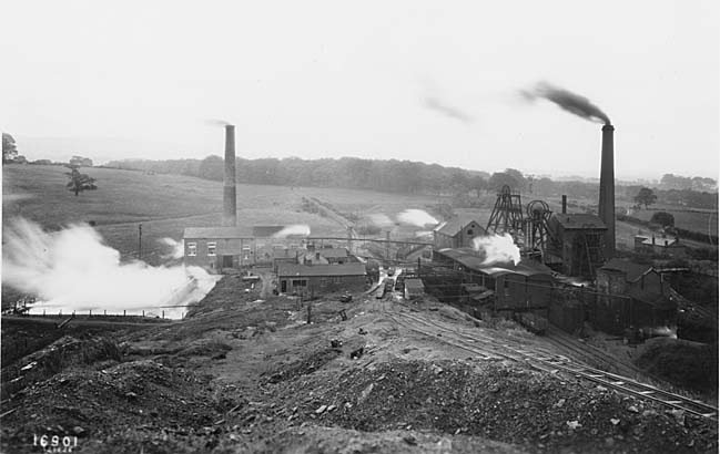
The other enduring and influential feature of Poynton is the Red Rock Fault, a major fault which runs approximately along the line of Towers Road. Everything to the west of this line is 600 feet lower so in effect the coal measures were far more difficult to reach. The area to the east, stretching towards Higher Poynton has several thick seams of coal, 44 feet in total thickness. This was much easier to mine than the thin seams in surrounding districts such as Marple or New Mills and eventually resulted in more than eighty mines being sunk over time in the village.

Park Pits, 1926. Screens (r centre), fan engine house (lower r), old railway incline (centre)
With that as background, we walked along Park Lane to Fountain Place, the junction with the Macclesfield Road. Although this is now the main shopping street for Poynton it is a relatively recent creation. Historically there have been two traditional centres for the village, neither of them on Park Lane. This was first built up in the 1890s and early 1900s but with houses, not with shops (hence the names of the terraces on each block.) When the street was made part of the “Shared Space” initiative a nod was made towards the history of the village and 50 stainless steel tiles were laid in the pavement, commemorating many of the more important mines. It’s a pity it was just a nod as most of the villagers and all of the visitors walk over them without noticing.
Fountain Place is now the centre of the village although the fountain has been pushed summarily to one side, having originally been in pride of place at the centre of the crossroads. The Macclesfield Road, the A523, was first developed as a turnpike from Bullock Smithy to Sandon in Staffordshire in 1762. The driving force sponsoring it was local merchants w anting an all-weather route to London and it was also strongly supported by a local carrier, Matthew Pickford. Sir George Warren employed John Metcalf, also known as Blind Jack of Knaresborough, to lay out the route through his estate. The road was built along an embankment which was constructed to create an artificial lake for the Warren estate, now known as Poynton Pool.
Displaced Fountain
There were other points of interest at the crossroads, not least being the “Shared space” traffic management. Not yet history but an important experiment which is bringing in traffic engineers from many countries to view it. The church which stands at the crossroads is of fairly recent origin as it replaced a chapel on the same site in 1858. All the records show that it was intended to be called St Mary’s but a last minute mistake resulted in it being called St George’s. Could it be that the main benefactor, Sir George Warren, had a hand in it?
[ For more on Poynton metalwork, stainless steel plates and gateway sculptures read this ]
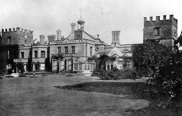
Walking north towards Hazel Grove we passed the Bull’s Head pub which was one of the two centres of the village but our destination was Poynton Pool and the estate which dominated the area for most of its history. There were three iterations of the hall which formed the nucleus of the e state. The original hall was built in the 1550s with the two iconic towers which became the eponymous symbol of the hall throughout its different phases. The Elizabethan core was extended with Jacobean and early Georgian extensions but in the 1750s a rich heiress married into the family and improved their fortunes dramatically. The old hall was demolished (except for the towers) and a new hall built close by in the fashionable classical style. This lasted a further century but by the mid 1800s the coal industry was encroaching so this hall too was demolished and a third built. (right) However, by now the Vernon family were lords of the manor and their main residence was in Derbyshire so, although various extensions were built, the hall was sold in 1911 to Walter Bright Hodgkinson, the chief executive of Hollins Mill in Marple.
From this point we concentrated on the coal industry. Because all the mines had one owner their exploitation was planned and comparatively efficient. Two railways led from the mines to the turnpike and then, at a later date to the railway. The course of the two main feeder lines are still obvious in the form of Prince’s Incline and Lady’s Incline, two straight paths leading towards Higher Poynton. Over the century when these routes operated technology improved and there were four main changes. Initially plate ways served the mines, similar to the Marple tramway but this was replaced by tram roads. These, in turn were followed by standard gauge rails operated by horse and rope and then finally by conventional locomotives.
After our stroll along Lady’s Incline we cut through to Poynton Green, the other centre for the original Poynton village. This in turn took us back to the civic centre and weaker souls bid us adieu. The rest went for a final sally to Lord Vernon’s Wharf. This was the loading place for coal on the Macclesfield Canal as not all the coal was shipped out by rail. A considerable amount, particularly in the early days went by canal. The mines also had a destructive influence on the canal as in parts the canal had collapsed into mine workings and a number of the bridges along the canal have had to be strengthened or modified over the years; not so much a symbiotic relationship, more a predatory connection.

Lord Vernon's Wharf
A fascinating journey through the history of Poynton. It really gave us all a much deeper understanding of how the village came to be and why it is as it is. The towns and villages around Marple have many threads in common but they are all distinct and different. Where can we go next year?
Hilary Atkinson - June 2021


