It can be hard to imagine that Mellor was once in the midst of a forest. Or perhaps not. It wasn’t ‘in the midst’ but right on the edge. And it wasn’t much of a forest anyway, even though it was called the Royal Forest of the High Peak. Yes, there were more trees than there are today but not many more.
At its height in the thirteenth century, an estimated one-fourth of the land area of England and its riches came under the special jurisdiction of forest law. Barons whose holdings lay within the royal forest were restricted in their use of the land, and the activity of all who lived or traveled in the forest was circumscribed. Until the institution of new taxes overshadowed the economic importance of the forest and the king divested himself of large areas of forest in 1327, the extent of the royal forest, with its special jurisdiction, was often a source of conflict between king and barons and was a major political issue in the Magna Carta crisis of 1215.
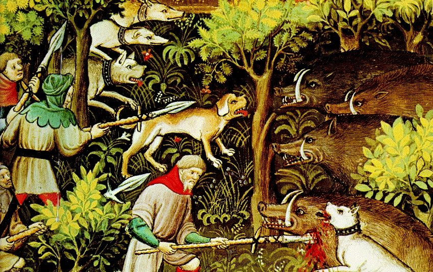
Hunting was a favourite pastime for the Norman nobility and, once William I (William the Bastard) had pacified his new conquest, he set aside large areas of land to be largely reserved for hunting. Although often called ‘Forests’ they were not forests in the modern sense. They were areas in which powerful individuals, usually the king, claimed for himself the right to hunt deer and protected that right through Forest Law. This was a set of regulations applying specifically to these areas, which protected both the game and its habitat. The Royal Forest of the Peak was typical of this procedure, although larger than most. When it was first established in the late eleventh century it comprised individual manors which had been confiscated from the Anglo-Saxon nobility and there were many gaps and areas between some of these. Gradually the ownership was consolidated to give large contiguous areas over which the deer and wild boars could range. This arbitrary expansion by the monarchy did not go unchallenged and the rights of freemen were finally restated and codified in the Charter of the Forest of 1217, a companion document to Magna Carta. Whereas Magna Carta dealt mainly with the rights of barons, the Charter of the Forest restored to the common man some real rights, privileges and protections against the abuses of the aristocracy.
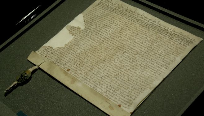 Charter of the Forest of 1217
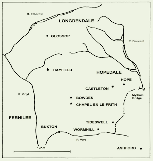
Throughout this process of growth, the boundaries of the Peak Forest continually changed but they were finally set in place at the Forest Pleas of 1281 in the time of Edward I and they remained largely unchanged until 1600. The boundary followed the major rivers of the area. The western boundary comprised the Goyt as far north as its junction with the Etherow. It then followed the Etherow along Longdendale to its headwaters then veered southwards following the Derwent as far as Mytham Bridge, just east of Hope. It then cut across country and joined the Wye to the south of Tideswell, turning westward towards the Goyt. In essence it comprised most of north west Derbyshire and at its greatest extent encompassed about 100 square miles.
It was divided into three divisions:
*Longdendale was in the north and west including both Ludworth and Mellor, and extending south to Hayfield and Kinder.
*Hopedale comprised the north and east part with the various tributaries of the Derwent and the major settlements of Castleton and Hope.
*Campana was the open limestone country to the south and south west, between the River Goyt and Castleton.
*Edale Cross marks where these three divisions met.
 The supreme authority of all royal forests was the king but he delegated this authority to various favourites. However, it remained within his gift and it could be (and was) taken away from time to time if the individual fell out of favour. The first custodian was William Peverel who was based at Peveril Castle near Castleton. It was taken back from the family by Henry II in 1154. Under succeeding monarchs the administration of the High Peak Forest passed to several different families but finally, in 1372 it was granted to John of Gaunt. When his son became King Henry IV, the Honour of the Peak passed to the Crown. Subsequently the manor and forest of High Peak were leased in perpetuity to the Cavendish family who became the dukes of Devonshire.
There was a hierarchy of control within the forests. The day-to-day task of protecting the game fell to the foresters. In the Peak Forest these were men who, in return for performing this service, were each granted a freeloading to provide them with a means of support. One of these forester estates was in Mellor and was held in the late thirteenth century by a family named de Meleur, after the place name. Their house was probably on the same site as present day Mellor Hall though it could have been where Bottoms Hall is today.
The forests reached their peak in the thirteenth century when it is estimated they covered a quarter of England but this control of the land purely for the pleasure of hunting, could not go on. The kings and nobles who controlled the forests always needed money and forest fines did not give sufficient income. Although the individuals entrusted with upholding forest law were themselves subject to its restrictions, they often got around or ignored these regulations. Consequently there was a gradual erosion of forest land by piecemeal clearance and enclosure of land within the forests for agricultural use. This was known as assarting, the greatest trespass that could be committed in a forest. To waste a forest involved felling trees and shrubs but they could grow again; to assart meant uprooting trees and taking the land completely out of forest use.
It was people in authority who were responsible for most of the assarts, not peasants expanding their plots by half an acre or so. In Mellor, from the 1220s onwards, the local foresters were adding to their existing farmland. In Ludworth, tenants of the abbey of Basingwerk were clearing land in the early thirteenth century with, at first, the tacit approval of the abbot but later with his overt approval. More land meant higher rents. Usually, once a fine had been imposed, these improvements were allowed to remain. The manor of Glossop which was within the royal forest, had been given to the Cistercian abbey of Basingwerk by the king in 1157. The Cistercians had a reputation for developing even the most unpromising land into profitable estates and Glossop was no exception. In 1253 it was reported that the woodland of Ludworth had been ‘wasted’ by the abbot. In 1285 these complaints resulted in an official enquiry, at which the abbot claimed, unsuccessfully, that his manor of Glossop lay outside the forest’s bounds. Nevertheless, the ultimate decision went in favour of the abbey. By a charter of 1290 the king gave the abbot and monks the right to clear for cultivation the woods and wastes within the manor of Glossop wherever they wished.
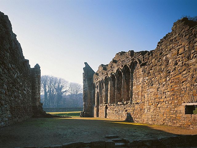 Cistercian Abbey of Basingwerk
The landscape of the commons was very different from today. There were no fields or drystone walls except for those on the edge of the moorland. Even within the cultivated parts the field boundaries were more likely to be hedgerows. Walls did not come into general use until the more widespread availability of black powder allowed stone to be quarried on a larger scale. This did not happen until the end of the sixteenth century/beginning of the eighteenth century.
The main routes onto the commons at this time were lengthy strips of common land projecting into the enclosed lands. They were used to gather livestock from the commons so were funnel-shaped or ‘horns’ as they were commonly known. To help this process they were frequently gated and many have pinfolds (walled enclosures) such as the one in the horn leading to Moor End. Animals found in the wrong flock after gathering would be put in the pinfold until collection by their owner. The horns were also used by travellers crossing the moors and therefore were often the focus for tracks.
Some parts of the commons on Cobden Edge and Ludworth Moor have defied improvement because they were too high, too steep or too wet to be useful. These still give an indication of what the wider commons looked like in the seventeenth century. Waterlogged areas and marshy hollows would have been extensive, supporting mosses and rushes. Trees would be present but confined to the more sheltered hollows where the slopes were too steep for grazing. The hill summits, particularly the sandstone outcrops, would have supported gorse and heather whilst lower slopes would be dominated by tough moorland grasses.

Forest Wall, Old Boundary of the Royal Forest of the Peak, Edale (Sep 2019) © National Trust
Between 1632 and 1640 Charles I, anxious to increase his income from the forest, decided to free the land from forest law and divide the commons and the wasted within each hamlet between the king and the freeholders and tenants. Two surveyors, Thomas Hibbert and Samuel Barton, were appointed and instructed to classify the land into ‘best, middle and worst sorts.’ And then divide each sort equally between king and tenants. They carried out their work in 1640, first establishing the boundary between the enclosed land and the commons. Farmhouses and other prominent features near the edge of the commons were shown as landmarks and then stakes were driven into the ground to show the proposed subdivisions. These were then labelled “King’s Part” or “Tenants’ Part.“
This break up of the forest was interrupted by the Civil War, the execution of the king and the interregnum of Parliamentary The last time that Forest Law was brought to bear was 1635 and by the time Charles II came to the throne in 1660 the idea of a Royal Forest was no longer valid. In France and Germany the royal forests became state forests where plantation forestry was taken up on a large scale much earlier; in England they just faded away and the parts that were not desired for agriculture became common land.
Further Reading:
Two books which may help to explain the landscape and vegetation of our local royal parks are:-
- Historic Landscapes of Mellor. £3.50
- Natural History of Ludworth. £3..50
